About 5 to 25 million years ago one of the largest flood basalts ever to occur on earth happened in the Pacific Northwest. These flood basalts spread across what is now Oregon, Washington and Idaho. There have been arguments that they even extended into far northern California and Nevada. In either case, they were huge and cover about 63,000 square miles. Scientific analysis of Argon and Potassium in these basalts indicate that the largest eruptions were from 17-14 million years ago and to a lesser extent from 14-6 million years ago.
The estimated volume of these basalt floods is over 41,500 cubic miles. While this is very large in human terms, it is not so in geological terms. It would take over 12,500 of these floods to equal the volume of the moon.
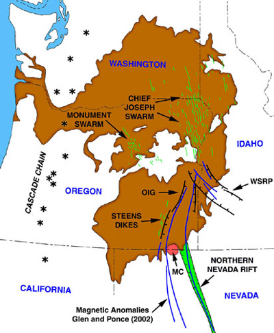
Here is a map from the Large Igneous Province Commission that shows the extent of these floods. The asterisks on the map show the location of the Cascade volcanos.
I first saw some of the features of this great province on a trip from near the California and Oregon border up Highway 395 on my way to Golden, Alberta, Canada. About 30 miles north of Lakeview, Oregon is Abert Rim and Lake. John Fremont discovered Abert Rim and Lake on December 20, 1843 and named it for his commanding officer The rim rises about 2,500 feet above the valley floor and can be seen for about 30 miles. Below it is one of the largest lakes in Oregon. I was totally fascinated by the view into earth's geologic past. The top 500-600 feet of the rim are almost vertical and the huge basalt cap of the rim is clearly evident. Here are two photos I took at the time.
Abert Rim 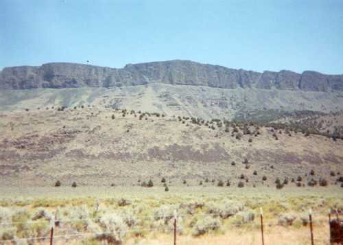
Abert Lake and Rim 